
Top trucking bottlenecks identified
2 min read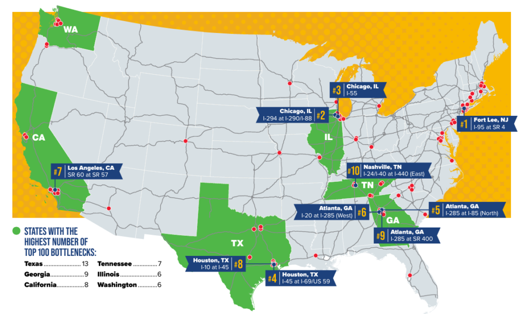
Since its inception in 2002, the American Transportation Research Institute (ATRI) has been at the forefront of collecting and analyzing truck GPS data to support various federal and state freight mobility initiatives. With an extensive database of freight truck GPS data, ATRI meticulously develops key performance measures to monitor the nation’s freight transportation system. One of its standout analyses is the ongoing truck bottleneck analysis, which pinpoints over 325 specific locations where traffic congestion significantly impacts truck-borne freight. Unlike other analyses that may identify congested corridors in a broad sense, ATRI’s dataset uniquely identifies granular chokepoints within the nation’s truck freight transportation system.
Understanding the performance of freight movement along the nation’s highways is paramount for making informed investment decisions. ATRI’s research equips stakeholders in both the private and public sectors with crucial information to grasp how congestion and delays impede mobility on the U.S. highway transportation system. The annual bottleneck list serves as a valuable tool, offering a clear roadmap to guide investment decisions, particularly as the nation seeks to address supply chain challenges through initiatives like the Infrastructure Investment and Jobs Act.
ATRI’s bottleneck analysis stands out for its incorporation of various unique components, including a vast database of truck GPS data from freight-significant locations nationwide and a sophisticated speed/volume algorithm that quantifies congestion’s impact on truck-based freight. Furthermore, the annual reports provide a chronological overview of mobility profiles, enabling analysts and planners to assess changes in congestion over time. This comprehensive approach allows for performance benchmarking and the identification of influential factors contributing to congestion and its implications for freight mobility.
The remaining top 10 bottlenecks include:
- Fort Lee, NJ: I-95 at SR 4
- Chicago: I-294 at I-290/I-88
- Chicago, IL: I-55
- Houston, TX: I-45 at I-69/US 59
- Atlanta, GA: I-285 at I-85 (North)
- Atlanta, GA: I-20 at I-285 (West)
- Los Angeles, CA: SR 60 at SR 57
- Houston, TX: I-10 at I-45
- Atlanta, GA: I-285 at SR 400
- Nashville, TN: I-24/I-40 at I-440 (East)
Source: ATRI